During the 2020 growing season, Dr. Eric Hunt of Atmospheric and Environmental Research, Inc. will be providing weekly updates of the soil moisture index (SMI) from the Noah-MP land surface model in the NASA LIS framework for the entire U.S. and regional analysis of the SMI over the four regions of U.S. where the majority of corn, soybean, wheat, and cotton production occurs. The analysis is intended to provide the larger agricultural and meteorological communities insight as to areas where soil moisture is excessive or deficient compared to average for that location and what that may mean for impacts. It is my goal that these maps can be an early warning signal for flash drought development or where flash flooding could be likely in the coming week if heavy precipitation materializes. Please be advised that the SMI should be viewed as complementary, not a substitute, to the U.S. Drought Monitor (USDM) and that declarations of drought or flash flood potential for a particular location should never be based on the SMI alone. The Evaporative Stress Index (ESI) is also included in our analysis (when available) as are various other maps that help give insight into current conditions across the U.S.
This blog post was partially supported by NASA grant 80NSSC19K1266.
Order of Maps and Tables in today’s Ag Blog
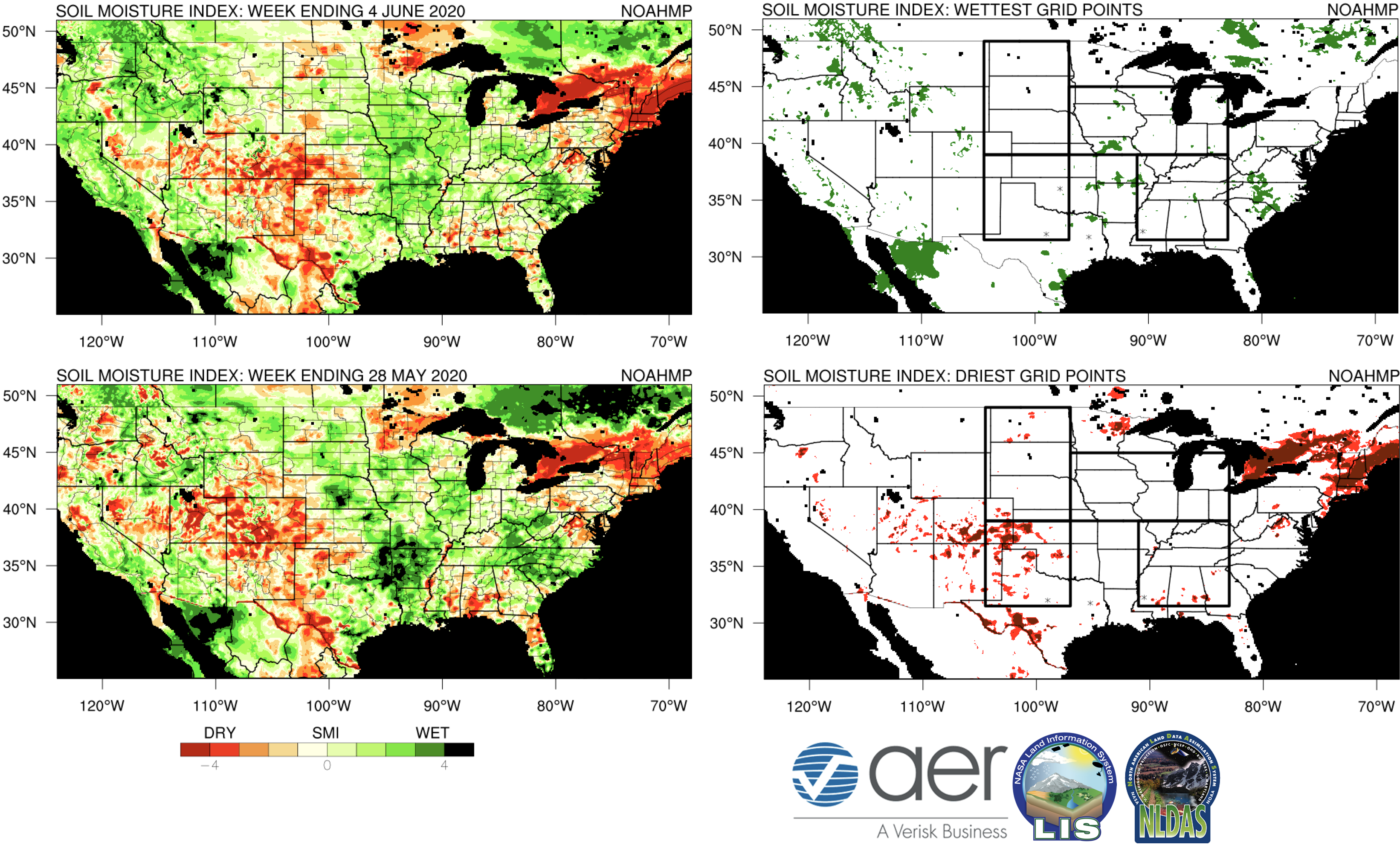
- Figure 1. Soil Moisture Index Panel (U.S., southern Canada, northern Mexico)
- Table 1. Regional Soil Moisture
- Figure 2. SPoRT LIS map
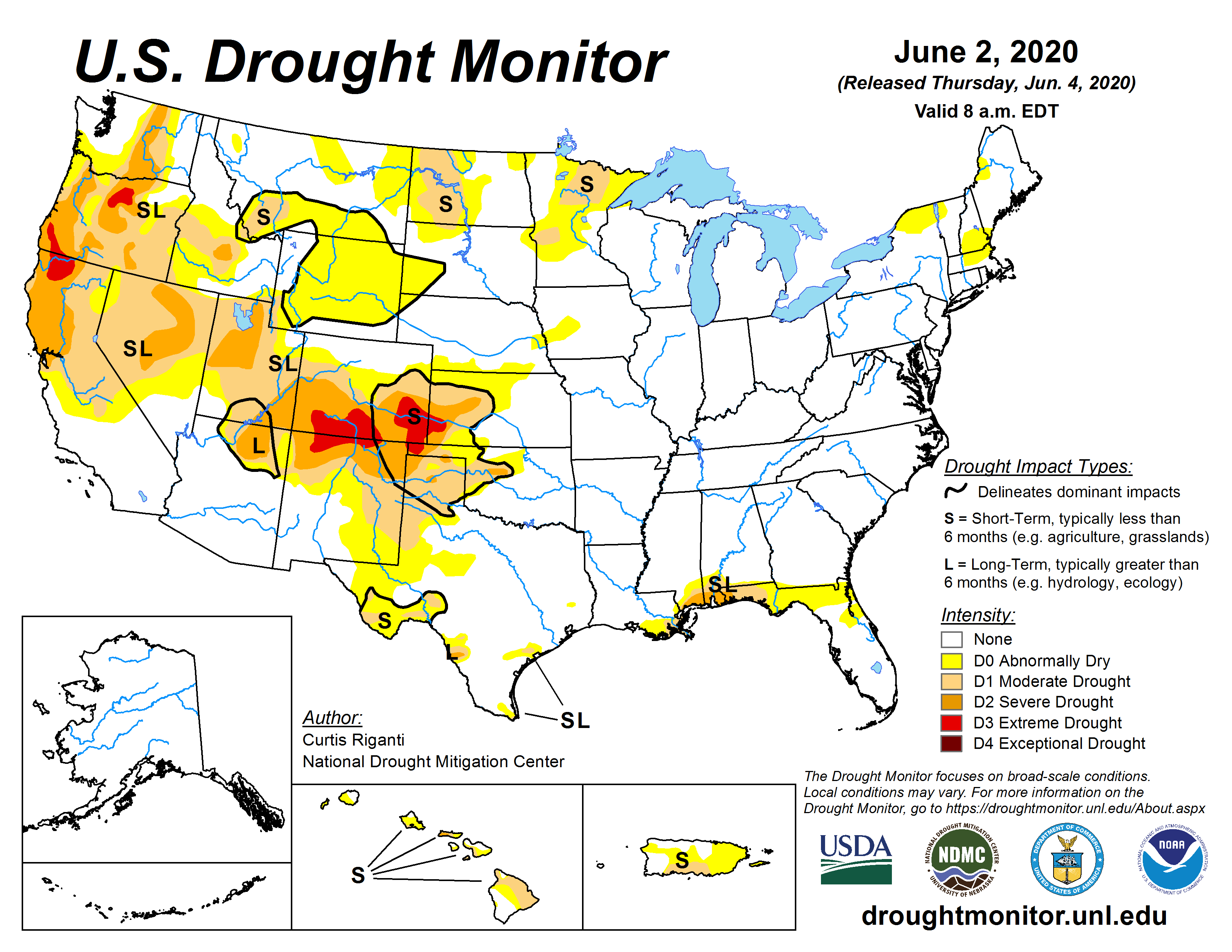
- Figure 3. U.S. Drought Monitor
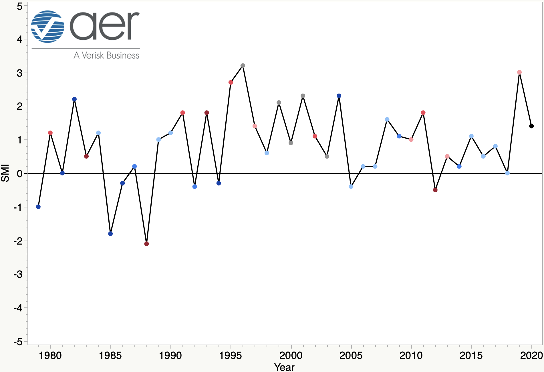
- Figure 4. Soil Moisture Index vs. Corn Trend
Narrative:
Much warmer temperatures returned to the central U.S. last week, running upwards of 15F above average for early June in parts of the western Corn Belt and northern Plains. While precipitation was not received everywhere across the Corn Belt over the past week, most places had received enough precipitation to keep the soils sufficiently moist (Figure 1) with a median SMI of 1.4 (Table 1) as of last Thursday morning. The root zone soil sas no doubt declined across much of the region since then, with the latest SPoRT LIS run from 00Z Monday morning indicating drying across the regions where temperatures this past weekend were most above average. But between a slow-moving cold front coming in from the west and remnants of Tropical Storm Cristobal moving up the Mississippi River Valley, most of the region should receive adequate, if not significant, precipitation over the next few days. This will be followed by a return to more seasonal temperatures so soils across the Corn Belt should remain favorably moist for at least a few more weeks even with minimal precipitation after tomorrow.
There are two main regions of concern on the dry side currently. First, the ongoing drought across portions of the central and southern High Plains (Figures 1-3). While this area of drought has not been that expansive to this point, the percentage of the Great Plains South region with an SMI below -3.0 nearly doubled over the previous week (i.e., from 10.4 to 18.8 percent). Though it was still under 20 percent, the forecast for the coming weeks is favorable for further deterioration to the south and southeast. Another area of concern is across New England, which has been quite dry over the past month and most of the region now has an SMI under -3.0. This hasn’t shown up as drought on the Drought Monitor just yet but this region also tends to get characterized as being in drought less frequently than other parts of the U.S., so if this dryness continues there will be some impacts to streamflow and small farms that dot that part of the U.S.
Much of the western U.S. is still listed in drought but the current SMI maps would indicate that improvement has occurred over the past several weeks. This is good because indications now are the latter half of the summer of 2020 favors more recent summers for that region, which means consistently warmer than average temperatures that lead to more atmospheric demand for moisture. The southeastern U.S. was mostly in decent shape as of last Thursday, with a median SMI of 0.2. Cristobal has already some drought relief to the Gulf Coast area and likely will help keep the agriculturally important Mississippi Delta region moist going into a more critical time for the corn and soybean crops.

Figure 1. The Soil Moisture Index (SMI) for the 7-day period ending 4 June 2020 (top left) and 28 May 2020 (bottom left). On the right hand side are the grid points where the SMI is at or above 3.0 (top right, red) and grid points where the SMI is at or below 3.0 (bottom right, red). Results are based on output from the 0-1 m (surface to 3.23 feet) layers in the Noah-Multiparameterization (Noah-MP) land surface model. Noah-MP is run in the NASA Land Information System (LIS) framework with the North American Land Data Assimilation Version 2 (NLDAS-2) forcing dataset. The SMI calculation is based on the soil moisture index created in Hunt et al. (2009) such that ‘5’(dark green) is the wettest and ‘-5’ (dark red) the driest for the period of record. The period of record used calculate the SMI for the current map is 1979-present.

Table 1. The regional median SMI value from the current map and the percentage of grid points in the four regions with SMI values greater than 3.0 and less than -3.0. Regions are indicated by the boxes in Figure 1. In the median column, red(blue) font indicates a decrease(increase) of more than 0.5 over the previous week. In the percentage columns, red font is used to indicate a region where the percentage of grid points ≤ -3.0 increased by more than 5 points and blue font is used to indicate a region where the percentage of grid points ≥ 3.0 increased by more than 5 points.

Figure 2. 0-100 cm relative wetness from the NASA Short-term Prediction Research and Transition Center (SPoRT) LIS simulation from 00Z on 8 June 2020.

Figure 3. U.S. Drought Monitor courtesy of the National Drought Mitigation Center.
It is too early to write-off possible issues from heat and/or a late-season flash drought but as of now, it is my opinion that there is very little chance for a significantly below trend corn crop this season. Figure 3 shows that the Corn Belt median SMI (as of last Thursday) was 1.4, which is on the wetter side of the spectrum but nowhere near as moist as last year at this time. As I mentioned in last week’s Ag Blog, there is definitely signal for slightly dry soils at this time of the season in a year with high end yields (dark blue circles) but such was also the case in 2012. Thus, while soil moisture at this point in the season can be helpful in determining final yields, there is a lot of season to go yet. In the AER Corn Yield forecast I put together a month ago, the outlook was for corn to finish around 183 bpa nationally. That forecast still seems on track, though I would bet the over and not the under on that number.

Figure 4. Median soil moisture index (SMI) at Week 23 from 1979-2020 and corn yield trend represented by the colored markers. Categories: Dark Blue > 10%, Blue +5 to 10%, Light Blue +1 to 5%, Gray -1 to 1%, Light Red -1 to -5 %, Red -5 to 10%, Dark Red <-10%.
Crop Summary
According to the latest Crop Progress Report, planting of the U.S. corn crop is nearly complete (97 percent) and soybean isn’t far behind at 86 percent. U.S. corn is currently rated at 75 percent Excellent/Good against 4 percent Poor/Very Poor. Soybean numbers are nearly identical at 72 and 4 percent respectively. No state with major production has more than 20 (10) percent of its corn (soybean) crop considered P/VP. The winter wheat crop is close to 90% headed with harvest beginning in some places. Wheat condition is decent overall, 51 percent E/G vs. 19 percent P/VP, with a higher percentage of poor crop conditions in Colorado and Oklahoma, likely corresponding with the drought. 78 percent of cotton has been planted across the U.S., with slower progress noted in Oklahoma and Missouri.
About the author:

Eric Hunt is an agricultural climatologist from Lincoln, NE and has several members of his extended family actively farming in Illinois and Nebraska. Eric has been with AER since 2012 and received his Ph.D. from the University of Nebraska. Among other activities, he is currently working on NASA funded projects to study the evolution of flash drought. He routinely blogs about agriculture and weather on the AER website. He can be reached via email at ehunt@aer.com and @DroughtLIS on Twitter.
About AER:
Founded in 1977, Atmospheric and Environmental Research is an award-winning environmental research, consulting and weather information services company with demonstrated expertise in numerical weather prediction, climate dynamics and radiation, circulation diagnostics, atmospheric chemistry, air quality and risk assessment, planetary sciences, remote sensing, satellite meteorology, and systems engineering. Consulting services are available. AER is a business unit of Verisk Analytics (VRSK). For more information, please visit our web site at www.aer.com.
Disclaimer: This report and the information and data contained herein (the Report) are wholly advisory in nature and are provided AS IS. AER makes no representations, covenants or warranties of any kind, either express or implied, with respect to the Report, including, without limitation, warranties of condition, quality, durability, suitability, merchantability or fitness for a particular purpose, or in respect of any warranty arising by statute or otherwise in law or from a course of dealing or usage of trade. The information included in the Report may be statistical samples and/or actuarial calculations and AER makes no warranties or representations, either express or implied, that the Report will accurately reflect, predict or resemble experience for an entire industry or any member or members of any industry. AER shall have no liability and shall not be responsible for business and legal conclusions, judgments and decisions made with respect to the Report. AER does not warrant and makes no representations regarding the completeness, currency, accuracy or predictive value of the Report. AER makes no representations and assumes no responsibility for the accuracy of the Report and is not responsible for errors resulting from omitted, misstated or erroneous information or assumptions.

