October 28, 2024
Dr. Judah Cohen from Atmospheric and Environmental Research (AER) embarked on
an experimental process of regular research, review, and analysis of the Arctic
Oscillation (AO) and Polar Vortex (PV). This analysis is intended to provide researchers
and practitioners real-time insights on one of North America’s and Europe’s leading
drivers for extreme and persistent temperature patterns.
During the winter schedule the blog is updated once every week. Snow accumulation
forecasts replace precipitation forecasts. Also, there is renewed emphasis on ice and
snow boundary conditions and their influence on hemispheric weather. In late Spring,
we transition to a spring/summer schedule, which is once every two weeks. Snow
accumulation forecasts will be replaced by precipitation forecasts. Also, there will be
less emphasis on ice and snow boundary conditions and their influence on hemispheric weather.
Subscribe to our email list or follow me on Twitter (@judah47) for notification of updates.
The AO/PV blog is partially supported by NSF grant AGS: 1657748
Summary
- The Arctic Oscillation (AO) is currently positive and is predicted to trend negative this week towards neutral as pressure/geopotential height anomalies across the Arctic are currently mostly negative and are predicted to become increasingly mixed over the next two weeks. The North Atlantic Oscillation (NAO) is currently positive with negative pressure/geopotential height anomalies across Greenland and the NAO is predicted to slowly trend negative towards neutral the next two weeks as pressure/geopotential height anomalies are predicted to remain negative to mixed across Greenland.
- This week troughing/negative geopotential height anomalies across Greenland will support ridging/positive geopotential height anomalies centered on Western Europe. Then next week as European ridging will consolidate north of the British Isles, supporting troughing over Eastern Europe. This pattern will support this week normal to above normal temperatures across Europe including the United Kingdom (UK) while low heights will support normal to below normal temperatures across Southern Spain. Then next week induced northwesterly flow will usher normal to below normal temperatures across Southeastern Europe.
- The general pattern predicted for Asia the next two weeks is ridging/positive geopotential height anomalies centered over Western Siberia forcing troughing/negative geopotential height anomalies across Eastern Siberia. However next week troughing will deepen across Western Russia. This pattern favors widespread normal to above normal temperatures across much of Asia with normal to below normal temperatures limited to Eastern Siberia this week, however next week the colder temperatures are predicted to persist across Eastern Siberia and spread across Western Russia.
- This general predicted pattern across North America is ridging/positive geopotential height anomalies south of the Aleutians, forcing troughing/negative geopotential height anomalies across Western Canada and the Western United States (US) with more ridging/positive geopotential height anomalies across eastern North America. Then in the first week of November the pattern is predicted to flip with ridging in western North America and troughing in eastern North America. This pattern favors normal to below normal temperatures across Alaska, Western Canda and the Western US with normal to above normal temperatures across Eastern Canada and the US east of the Rockies. However, during the first week of November colder temperatures will filter into the Eastern US.
- In the Impacts section I discuss some early signs of the polar vortex and how it may impact the upcoming winter weather in the Northern Hemisphere (NH).
Plain Language Summary
The rapid advance of snow cover across Asia that dominated the first half of October has officially crashed and burned (see Figure i). This pretty much guarantees a weak signal at best using snow cover as a predictor for the upcoming winter. In the shorter term, the polar vortex is predicted to strengthen (see Figure 12b) and this will likely maintain warmer weather for eastern North America and northern Eurasia (see Figure 9) for the foreseeable future. Some exceptions are western North America, Southeastern Europe, Western Russia (reminsicnet of last winter) and Eastern Siberia.
Impacts
As happens all month long in October, my focus is on the snow cover advance across Siberia and what impact it may have on the stratospheric polar vortex (PV). More extensive snow cover across Eurasia in October, and this mostly confined to Siberia, the more likely the PV will be weaker than normal during the winter months that favors widespread colder temperatures across the Northern Hemisphere (NH) but in particular in East Asia and the US east of the Rockies. It also includes Northern Europe, but the relationship is weaker across Europe and in my own research rarely is it statistically significant. Other research emphasizes November as an important month as discussed below, something that I consider as well.
As I discussed last week, the snow cover extent across Eurasia got out of the gate quickly with snow cover extent (SCE) higher than any of the previous nine years through the second week of October and then fell back to normal the past week and a half. I include the latest update to the plot of daily Eurasian SCE so far in October in Figure i. The black dashed line represents the mean value using October 2009 through 2023.
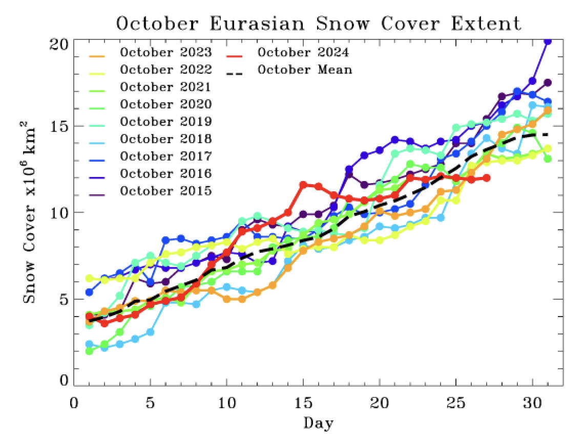
Figure i. Observed daily Eurasian snow cover extent through 27 October 2024. Included are the daily values from October 2015 through 2023 and the mean value the mean value from October 2009 through 2023 (black dashed line).
I was pretty dramatic in describing the snow advance pullback even though the snow cover extent was at the time normal to above normal. But I knew the circulation pattern was hostile to further advance of snow cover in the short term across Eurasia and this week’s update shows Eurasian SCE currently at a decadal low. The outlook still doesn’t look great, but I expect new advancement of SCE to the west given the predicted strong troughing in Western Russia and the Urals. I still believe the final value for October 2024 will be close to the past four years, unless something almost unprecedented occurs over the next week or so.
As I have discussed in previous blogs at this time of year on the possible importance of November SCE. Since my own research on October SCE and the winter PV and NH temperature anomalies, subsequent research has found a relationship between a dipole in SCE anomalies across Eurasia in November and the winter PV and temperature anomalies where below normal SCE in western Eurasia with above normal SCE in eastern Eurasia favor a weaker PV and colder NH temperatures (for example Park et al. 2020 and Wegmann et al. 2020). That dipole that favors a weaker PV and colder temperatures is currently observed (see Figure ii). Of course, the research is for the month of November, and it is only October and based on the weather model forecasts I would expect this dipole to disappear in early November. But when you are grasping at straws, here is a straw we can all grasp on to for what it’s worth.
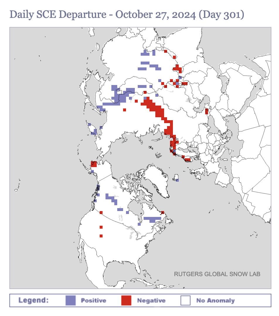
Figure ii. Observed daily snow cover extent anomalies on 27 October 2024. Included are the daily values from October 2015 through 2023 and the mean value from October 2009 through 2023 (black dashed line). Plot taken from: http://climate.rutgers.edu/snowcover/index.php.
While we are grasping at straws, another possible bright spot is that SCE across North America, which has really picked up over the past week. North American SCE is a little above normal after being well below normal. SCE has spread across all of Northern Canada and will spread across Western Canada in the coming week or so. Probably favors colder weather in western North America but that could still change.
Another signal that I am watching closely and will over the next couple of months is Arctic sea ice extent which continues to grow relatively slowly for now. As I expected in last week’s blog, sea ice growth occrurred preferntially in the North Pacific sector relative to the North Atlantic sector (see Figure iii). This is important becaue it is the lack of sea ice in the Barents Kara Seas that favors a weak PV. However looking at the weather forecasts over the next two weeks (e.g., Figures 8 & 9), the pattern probably favors sea ice growth in the North Atlantic sector but maybe also in the North Pacific sector. Therefore which region will feture the largest negative anomalies in the coming months remains for now uncertain.
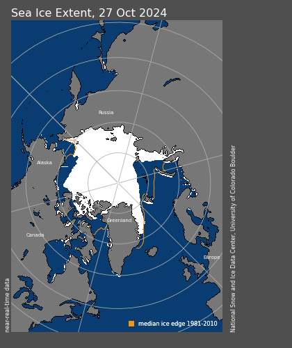
Figure iii. Observed Arctic sea ice extent on 27 October 2024 (white). Orange line shows climatological extent of sea ice based on the years 1981-2010. Image from the National Snow and Ice Data Center (NSIDC). URL: https://nsidc.org/sea-ice-today.
The PV is predicted to strenthen significantly (see Figure 12b) which favors an overall warmer pattern across the NH and as long as the troughing remains anchored near the Urals there is little reason for the PV to weaken very much. One curious note is that the PV does seem to develop this pseudo stretching or kinks that are associated with brief shots of clder weather to the East Coast of Canada and the US. Does this strengthen with time into more impressive cold shots to the East Coast? Pure speculation but certainly has me take notice.
I will end with this cautionary tale for winter 2024/25 and I think I struck a similar chord last year at this time. Could infanticide be perpetrated on winter 2024/25? We have a predicted strong PV and a lack of high lattiude blocking in the troposphere. If these two features link up, they can reinforce each other and create a virtuous cycle where a warm pattern begets more warm weather. In Figure 11 the polar cap geopotential height anomalies (PCHs) forecast, is suggestive of this coupling at the end of the first week of November. I don’t want to be overly dramatic of a runaway warm winter (rereading this, I do sound a bit schizophrenic). The coupling that I described has happened in mid-November and early December for the past four years with varying outcomes during the winter months.
As I discussed last week, what could finally change the pattern around are the warm/postive polar cap geopotential height anomalies (PCHs) that are shown to descend from the lower stratoisphere to the lower troposphere now in mid-November (see Figure 11). The models seem to be consolidating around increasing high latitude blocking in the Central and/or North Atlantic sector of the Arctic including Greenland blocking. This could start a more favorable pattern of a wintry pattern in the Eastern US and northern Eurasia. But overall looks mild for the foreseeable future and any pattern change is likely to take time.
Wednesday Update
We are here for the good, the bad and the ugly and the latest Eurasian snow cover extent (SCE) plot definitely falls into the category of the ugly. Eurasian snow cover extent is clearly lost and needs to find its way back (see Figure iv). In contrast, North American snow cover extent has had a nice spurt and is close to the total value of Eurasia SCE, something unusual. I still think that the Eurasian SCE will pick up as colder air settles across the Urals and Western Russia.
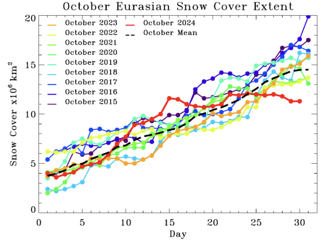
Figure iv. Observed daily Eurasian snow cover extent through 29 October 2024. Included are the daily values from October 2015 through 2023 and the mean value the mean value from October 2009 through 2023 (black dashed line).
Otherwise overall the troughing predicted near the Urals with ridging over Siberia are nearly optimal for strengthening the PV. This will likely favor an overall mild pattern for weeks to come. Waiting to see if the high pressure ridging near northwest Europe can get into a position to force a different pattern. No strong signs of this and it will take time. But all in all, most signs are points to at least a warm start to winter and there isn’t much evidence to think the opposite is more likely.
Near-Term
This week
The AO is predicted to be positive this week (Figure 1) with mostly negative geopotential height anomalies across the Arctic and with mixed geopotential height anomalies across the mid-latitudes of the NH (Figure 2). With predicted negative geopotential height anomalies across Greenland (Figure 2), the NAO is predicted to be positive this week.

Figure 1. The predicted daily-mean AO at 1000 hPa from the 00Z 28 October 2024 GFS ensemble. Gray lines indicate the AO index from each individual ensemble member, with the ensemble-mean AO index given by the red line with
squares.
This week, troughing/negative geopotential height anomalies across Greenland will support rdging/positive geopotential height anomalies centered on Northwestern Europe with the exception of a closed low over Gibraltar this week (Figures 2). This pattern will favor normal to above normal temperatures across Europe including the UK while low heights favor normal to below normal temperatures across Southern Spain (Figure 3). This week the predicted pattern across Asia is ridging/positive geopotential height anomalies centered over Western Siberia forcing troughing/negative geopotential height anomalies across Eastern Siberia (Figure 2). This pattern favors normal to above normal temperatures across much of Asia with normal to below normal temperatures limited to Eastern Siberia (Figure 3).
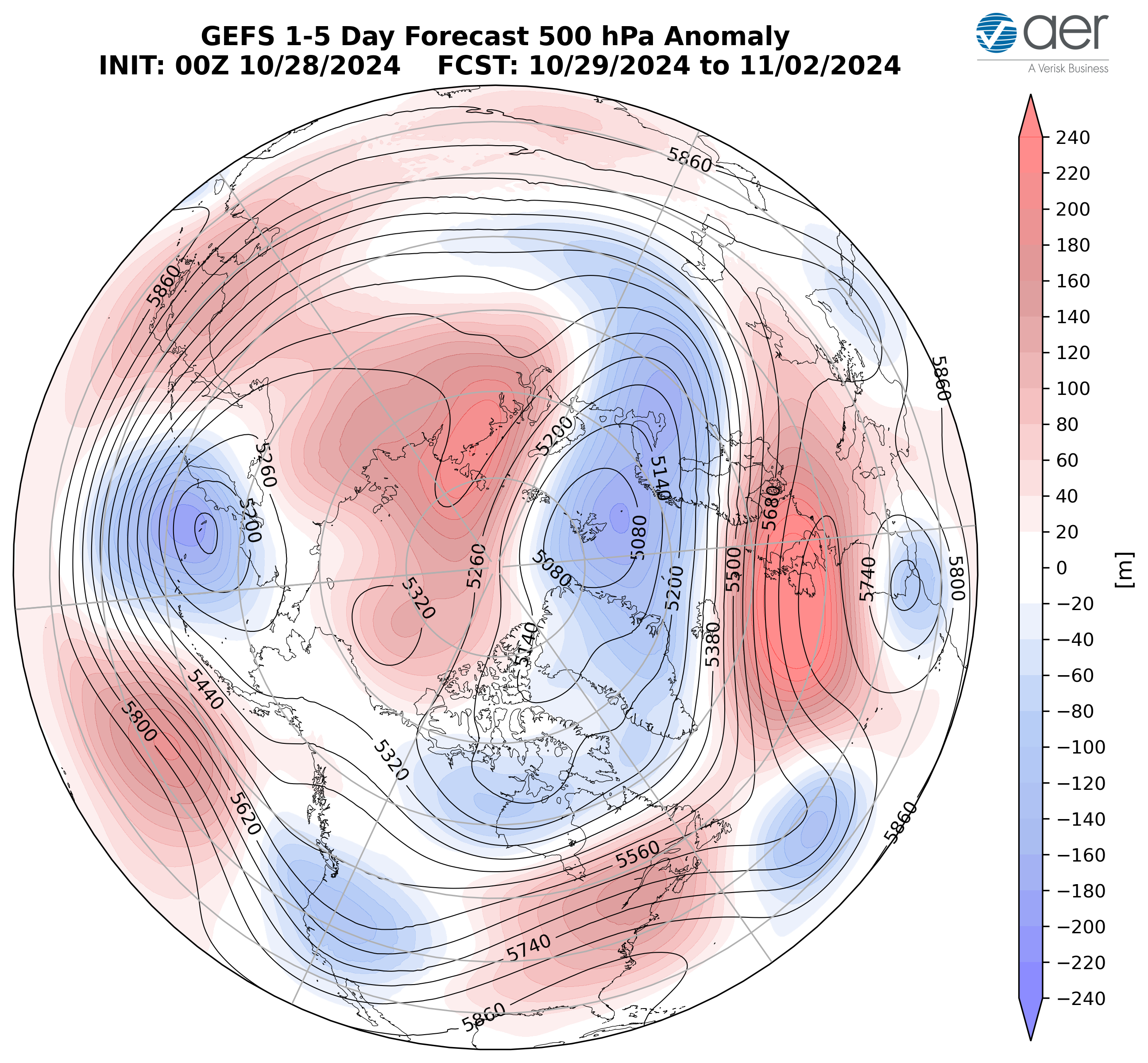
Figure 2. Forecasted average 500 mb geopotential heights (dam; contours) and geopotential height anomalies (m; shading) across the Northern Hemisphere from 29 October – 2 November 2024. The forecasts are from the 00z 28 October 2024 GFS ensemble.
This week ridging/positive geopotential height anomalies south of the Aleutians, forcing troughing/negative geopotential height anomalies across Western Canada and the Western US with more ridging/positive geopotential height anomalies across eastern North America. (Figure 2). This pattern will favor normal to below normal temperatures across Alaska, Western Canada and the Western US with normal to above normal temperatures across Eastern Canada and the Eastern US (Figure 3).

Figure 3. Forecasted surface temperature anomalies (°C; shading) from 29 October – 2 November 2024. The forecast is from the 00Z 28 October 2024 GFS ensemble.
Troughing and/or cold temperatures will support new snowfall across Scandinavia and parts of Siberia while warm temperatures will support snowmelt in Western Siberia and the Tibetan Plateau this week (Figure 4). Troughing and/or cold temperatures will support new snowfall across southern Alaska, Northern and Western Canada and the higher elevations of the Western US while warm temperatures will support snowmelt in Eastern Canada this week (Figure 4).

Figure 4. Forecasted snow depth changes (mm/day; shading) from 29 October – 2 November 2023. The forecast is from the 00Z 28 October 2023 GFS ensemble.
Near-Mid Term
Next week
With geopotential height anomalies turning more mixed across the Arctic and with mixed geopotential height anomalies across the mid-latitudes this period (Figure 5), the AO will likely be positive to neutral this period (Figure 1). With predicted weak but negative pressure/geopotential height anomalies across Greenland (Figure 5), the NAO will likely persist positive this period.
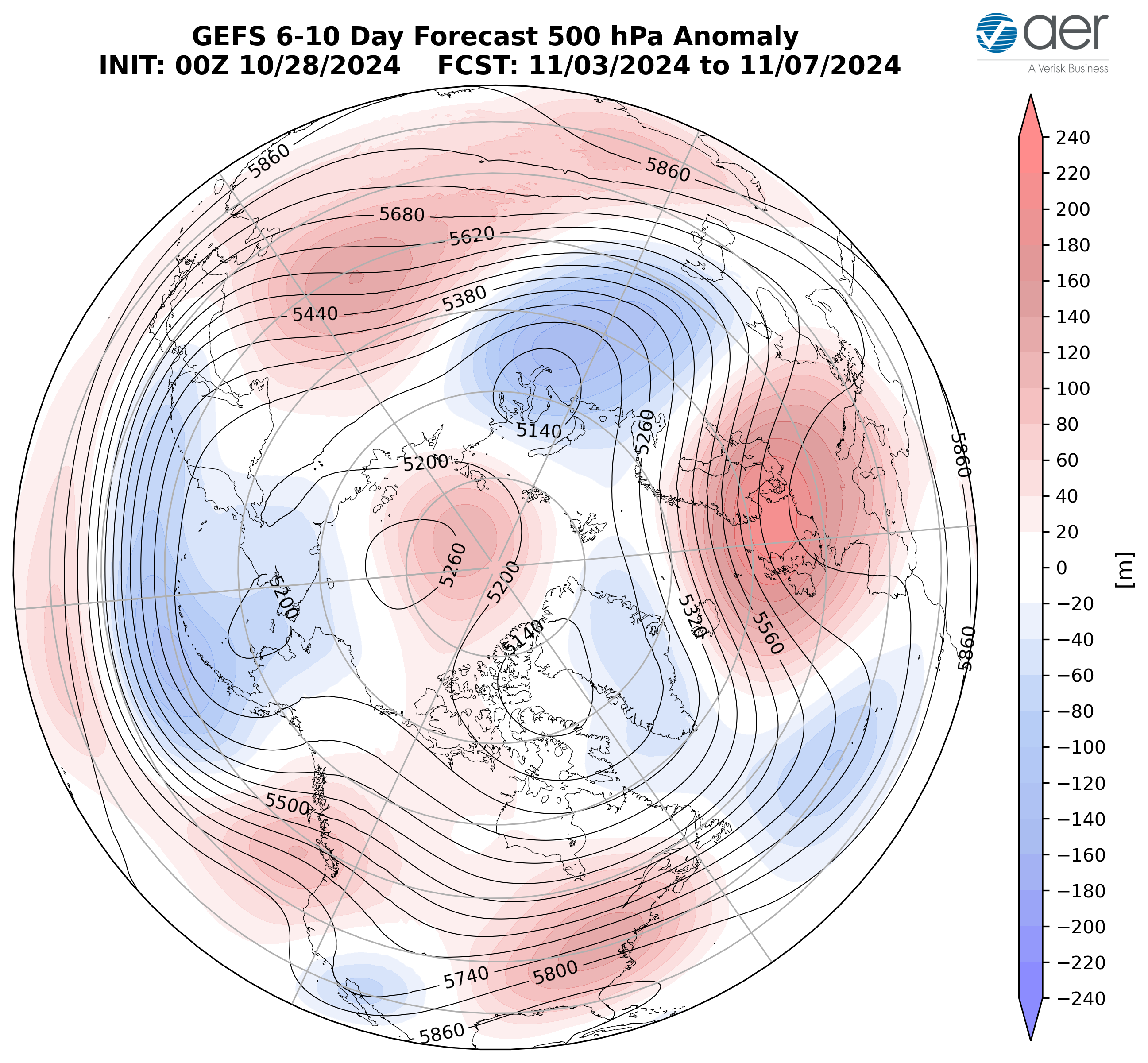
Figure 5. Forecasted average 500 mb geopotential heights (dam; contours) and geopotential height anomalies (m; shading) across the Northern Hemisphere from 3 – 7 November 2024. The forecasts are from the 00z 28 October 2024 GFS ensemble.
Weakening troughing/negative geopotential height anomalies across Greenland will continue to support ridging/positive geopotential height anomalies across Northwestern Europe with troughing in Southeastern Europe this period (Figure 5). This pattern will favor normal to above normal temperatures across much of Europe including the UK while induced northerly flow will usher in normal to below normal temperatures across Southeastern Europe (Figures 6). The predicted pattern across Asia is ridging/positive geopotential height anomalies centered over the Laptev Sea forcing troughing/negative geopotential height anomalies across the Urals and Eastern Siberia with more ridging/positive geopotential height anomalies across East Asia (Figure 5). This pattern favors widespread normal to above normal temperatures across much of Asia with normal to below normal temperatures limited to Western Russia and Eastern Siberia (Figure 6).

Figure 6. Forecasted surface temperature anomalies (°C; shading) from 3 – 7 November 2024. The forecasts are from the 00z 28 October 2024 GFS ensemble
Troughing/negative geopotential height anomalies across Alaska and the Aleutians, will force ridging/positive geopotential height anomalies across Western Canada, the Northwestern and the Eastern US this period (Figure 5). This pattern will favor normal to above normal temperatures across Alaska, Western Canada, the Northwestern and Eastern US with normal to below normal temperatures limited to Northeastern Canada and the Southwestern US (Figure 6).

Figure 7. Forecasted snow depth changes (mm/day; shading) from 3 – 7 November 2024. The forecasts are from the 00z 28 October 2024 GFS ensemble.
Troughing and/or cold temperatures will support new snowfall across the Caucasus, the Urals, Siberia and the Tibetan Plateau while warm temperatures will support snowmelt in Norway and Southern Siberia this week (Figure 7). Troughing and/or cold temperatures will support new snowfall across Alaska, Northern and Western Canada and Colorado while warm temperatures will support snowmelt in British Columbia this week (Figure 7).
Mid Term
Week Two
With predicted mixed to positive geopotential height anomalies across the Arctic and mixed geopotential height anomalies across the mid-latitudes this period (Figure 8), the AO will likely persist near neutral this period (Figure 1). With predicted mixed to positive pressure/geopotential height anomalies across Greenland (Figure 8), the NAO will likely be neutral this period as well.
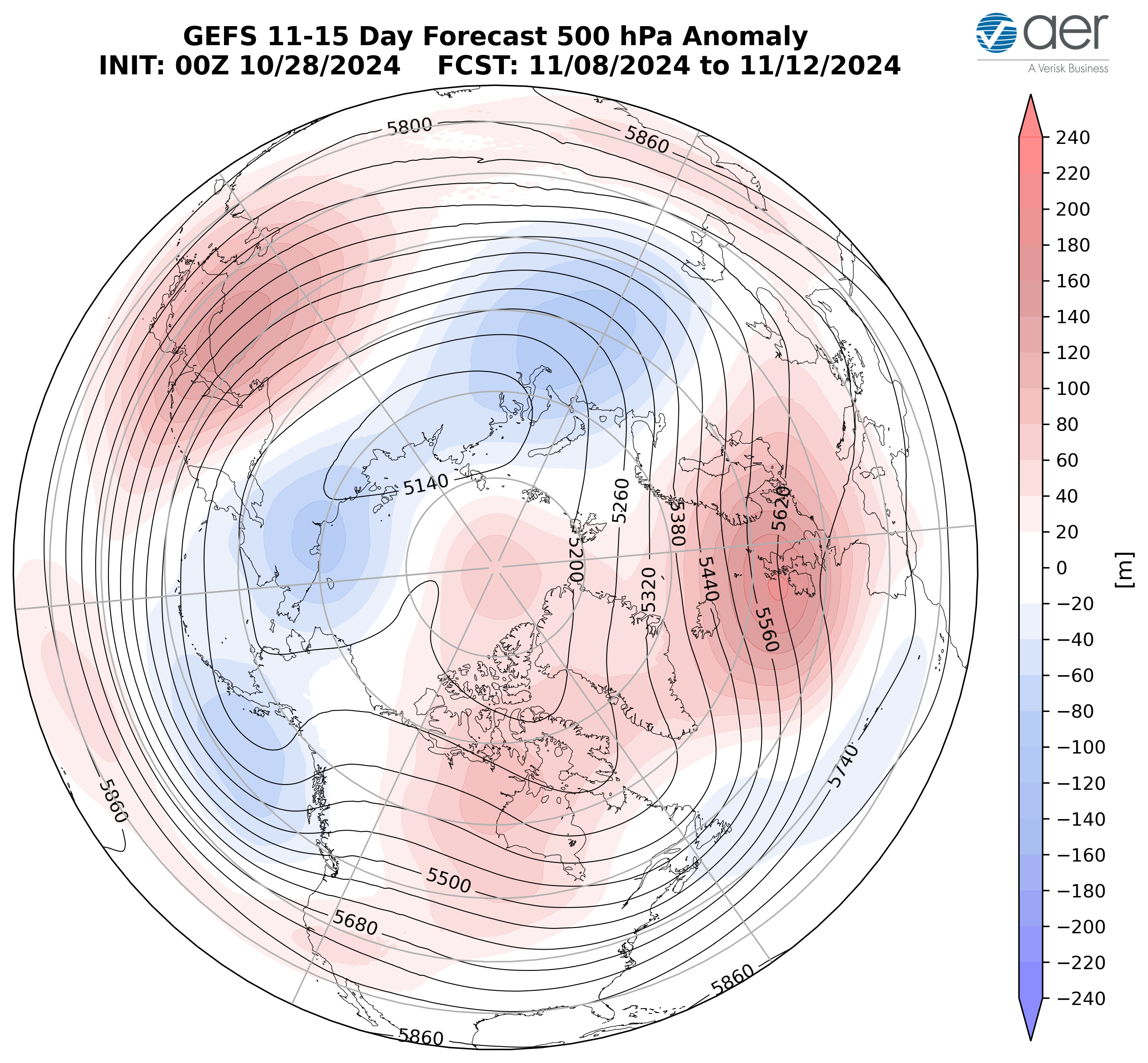
Figure 8. Forecasted average 500 mb geopotential heights (dam; contours) and
geopotential height anomalies (m; shading) across the Northern Hemisphere from 8 – 12
November 2024. The forecasts are from the 00z 28 October 2024 GFS ensemble.
Increasing ridging/positive geopotential height anomalies centered between the UK and Iceland is predicted to extend into Northwestern Europe and will persist troughing/negative geopotential height anomalies across Southeastern Europe this period (Figure 8). This pattern should favor normal to above normal temperatures across Western and Northern Europe including the UK with normal to below normal temperatures across Southeastern Europe this period (Figures 9). The predicted pattern across Asia this period is ridging/positive geopotential height anomalies widespread across Southern and Eastern Asia and centered on Eastern China with troughing/negative geopotential height anomalies across Western Russia and Northern Siberia this period (Figure 8). The predicted pattern favors widespread normal to above normal temperatures across much of Asia with normal to below normal temperatures limited to Western Russia, parts of Northern and Eastern Siberia this period (Figure 9).

Figure 9. Forecasted surface temperature anomalies (°C; shading) from 8 – 12
November 2024. The forecast is from the 00Z 28 October 2024 GFS ensemble.
Predicted persistent troughing/negative geopotential height anomalies across Alaska, the Gulf of Alaska, the West Coasts of Canada and the US will force ridging/positive geopotential height anomalies across Central Canada and the Central US with more troughing in the Canadian Maritimes and the Northeastern US this period (Figure 8). This pattern will favor widespread normal to above normal temperatures across much of Alaska, Canada and the US with normal to below normal temperatures limited to Eastern Canada and the Northeastern US this period (Figure 9).

Figure 10. Forecasted snow depth changes (mm/day; shading) from 8 – 12 November 2024. The forecast is from the 00Z 28 October 2024 GFS ensemble
Troughing and/or cold temperatures will support new snowfall across Norway, the Urals, Siberia and the Tibetan Plateau this week (Figure 10). Troughing and/or cold temperatures will support new snowfall across Alaska, Northern and Western Canada, the Canadian Maritimes and the higher elevations of the Northwestern US this week (Figure 10).
Longer Term
30–day
The latest plot of the polar cap geopotential height anomalies (PCHs) currently shows normal to warm/positive PCHs in the lower stratosphere and the upper troposphere with cold/negative PCHs in the upper stratosphere and the lower to mid-troposphere (Figure 11). This week and into next week warm/positive mid tropospheric PCHs are predicted to descend close to the surface while cold/negative PCHs are predicted to expand into the mid-and lower-stratosphere (Figure 11).
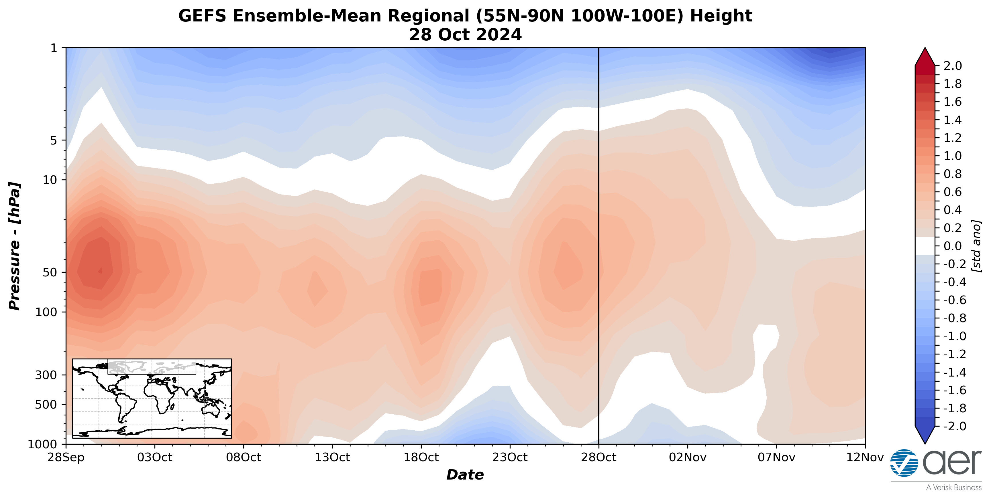
Figure 11. Observed and predicted daily polar cap height (i.e., area-averaged
geopotential heights poleward of 60°N) standardized anomalies. The forecast is from the 00Z 28 October 2024 GFS ensemble.
The predicted negative PCHs in the lower troposphere this week (Figure 11) are consistent with the predicted positive surface AO this week (Figure 1). However, the AO is predicted to become neutral starting next week (Figure 1) coinciding with the predicted descending of warm/positive PCHs into the lower troposphere (Figure 11).
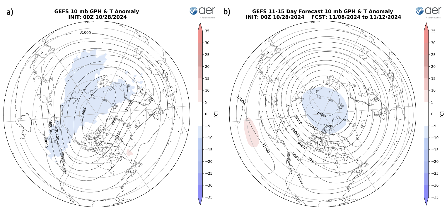
Figure 12. (a) Initialized 10 mb geopotential heights (dam; contours) and temperature anomalies (°C; shading) across the Northern Hemisphere for 28 October 2024. (b) Same as (a) except forecasted averaged from 8 – 12 November 2024. The forecasts are from the 00Z 28 October 2024 GFS model ensemble.
This week the polar vortex (PV) is predicted to be contorted in shape where it is elongated along an axis from Western Siberia to Western Canada with the PV center near the North Pole (Figure 12a). The elongation of the PV center is a result of a quick hitting stretched PV disruption. However, for the second week of November the PV center is predicted to shift to the Kara Sea and becoming more circular in shape (Figure 12b). This is a classical strong PV configuration that favors mild temperatures across Northern Europe, Northern Asia and North America east of the Rockies.
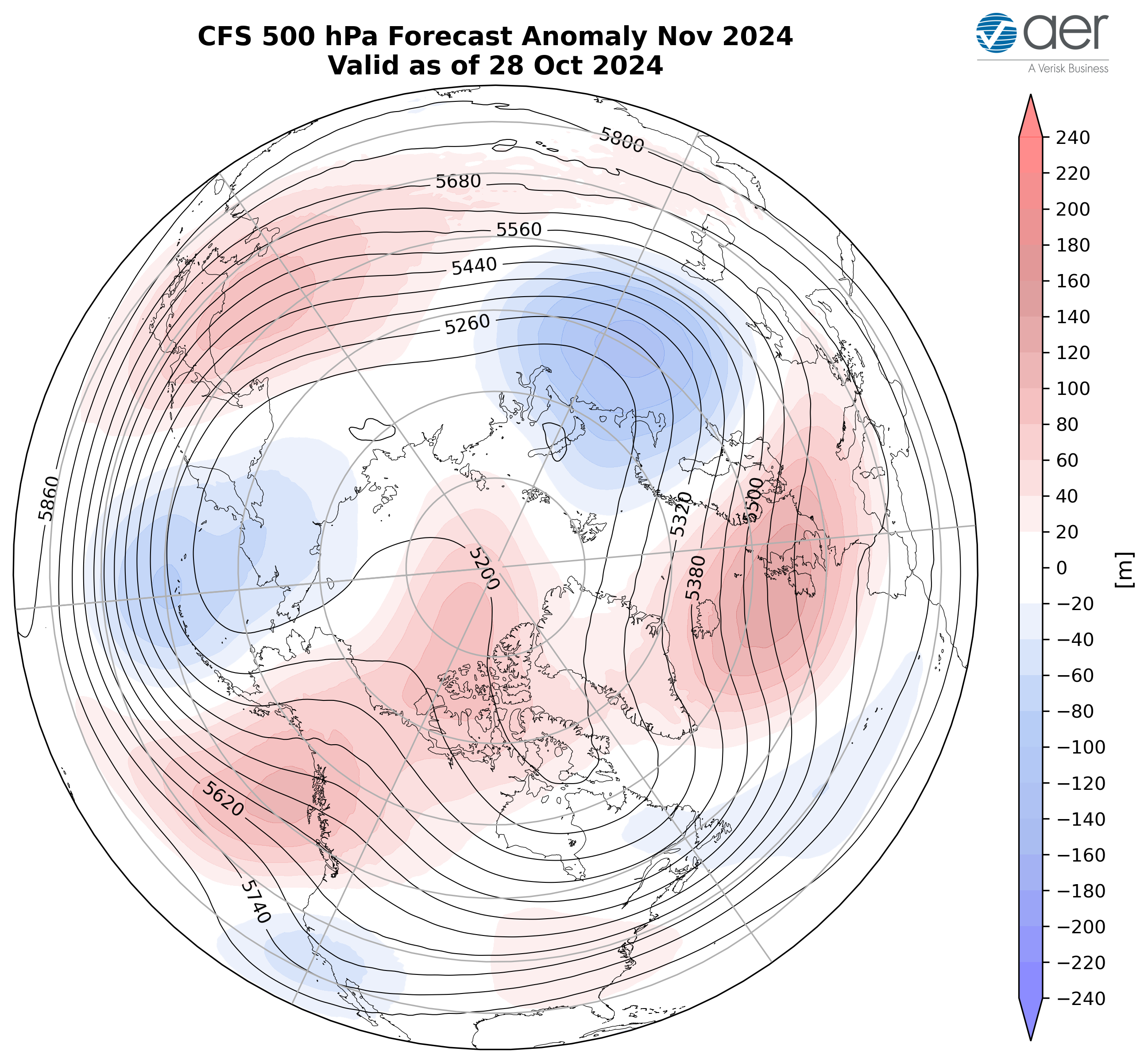
Figure 13. Forecasted average 500 mb geopotential heights (dam; contours) and geopotential height anomalies (m; shading) across the Northern Hemisphere for November 2024. The forecasts are from the 00Z 28 October 2024 CFS.
I include in this week’s blog the monthly 500 hPa geopotential heights (Figure 13) and surface temperatures for November (Figure 14) from the Climate Forecast System (CFS; the plots represent yesterday’s four ensemble members). The forecast for the troposphere is ridging centered between Iceland and the UK, East Asia, the Gulf of Alaska extending towards the North Pole with troughing spread across Western Russia, Eastern Siberia extending to the Dateline and the Aleutians, the Southwestern US and Eastern Alaska (Figure 13). This pattern favors seasonable to relatively warm temperatures across Western Europe, much of Asia including Western and Central Siberia, Alaska, Northern and Western Canada and the US with seasonable to relatively cold temperatures across Eastern Europe, Western Russia, Eastern Siberia, Eastern Canada, the Southwestern and Northeastern US (Figure 14).
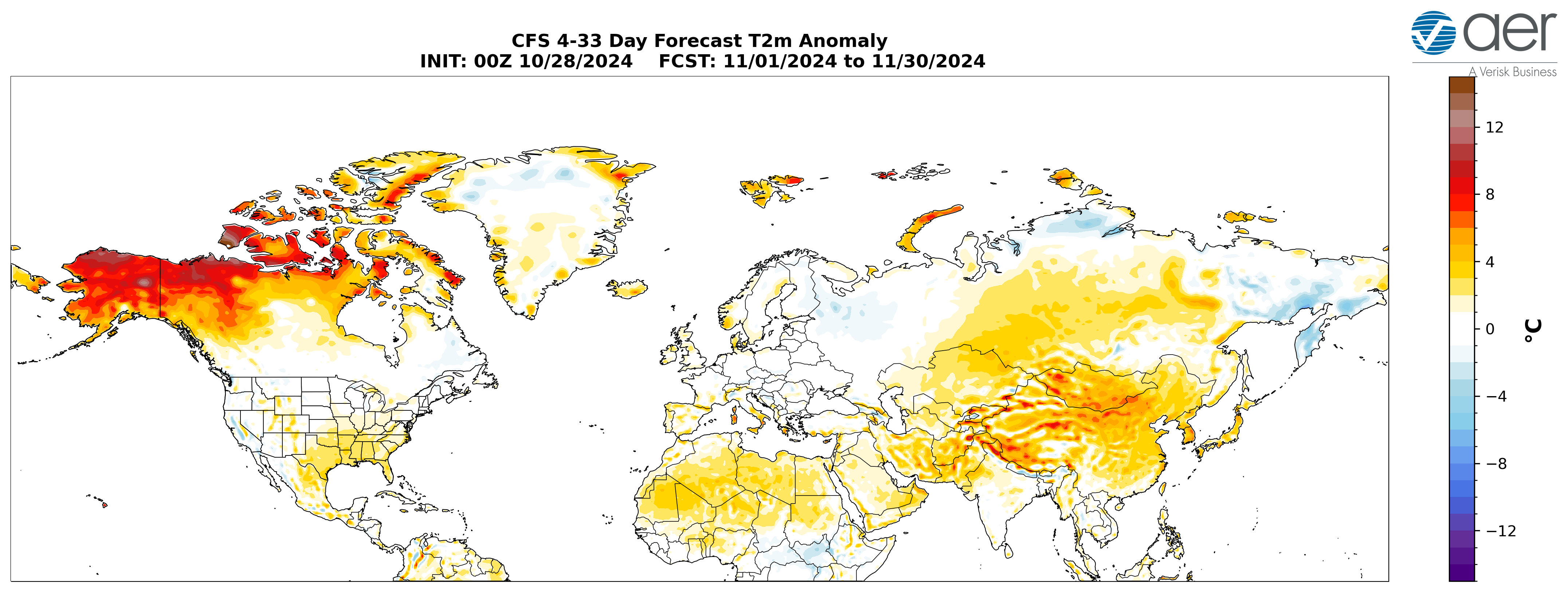
Figure 14. Forecasted average surface temperature anomalies (°C; shading) across
the Northern Hemisphere for November 2024. The forecasts are from the 00Z 28 October 2024 CFS.
Boundary Forcings
SSTs/El Niño/Southern Oscillation
Equatorial Pacific sea surface temperatures (SSTs) anomalies are below normal, between the Dateline and the South America coast, indicating that an La Niña is emerging (Figure 15) and weak La Niña conditions are expected through the winter. Observed SSTs across the NH remain well above normal especially in the central North Pacific centered on teh Dateline and the western North Pacific, much of the North Atlantic and offshore of eastern North America though below normal SSTs exist regionally especially in the South Pacific.
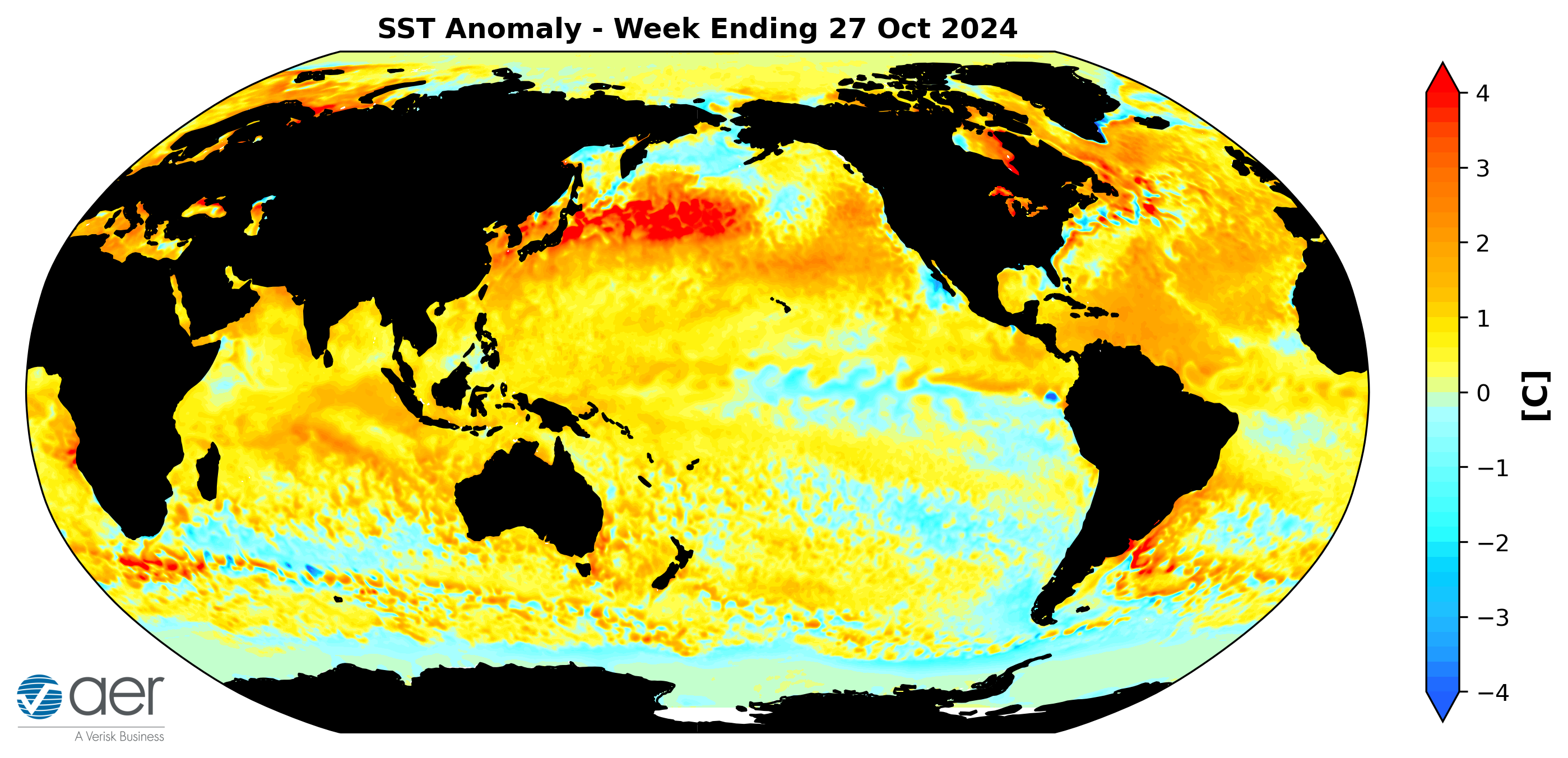
Figure 15. The latest daily-mean global SST anomalies (ending 27 October 2024).
Data from NOAA OI High-Resolution dataset. Source: https://psl.noaa.gov/map/clim/sst.shtml
Madden Julian Oscillation
Currently the Madden Julian Oscillation (MJO) is currently in phase six (Figure 16). The forecasts are for the MJO to rifle quickly through phases six, seven, eight and one over the next two weeks. Phase six favors troughing in western North America and ridging in eastern North America. Therefore it seems that the MJO icould be having some influence on North American weather next week. But admittedly this is outside of my expertise.
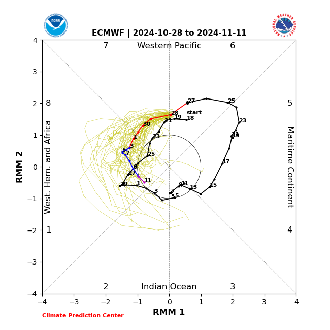 Figure 16. Past and forecast values of the MJO index. Forecast values from the 00Z 28 October 2024 ECMWF model. Yellow lines indicate individual ensemble-member
forecasts, with the green line showing the ensemble-mean. A measure of the model
“spread” is denoted by the gray shading. Sector numbers indicate the phase of the
MJO, with geographical labels indicating where anomalous convection occurs during
that phase. Image source: https://www.cpc.ncep.noaa.gov/products/precip/CWlink/MJO/CLIVAR/ecmf.shtml
Get Detailed Seasonal Weather Intelligence with sCast
We appreciate your taking the time to read the public Arctic Oscillation blog from Dr. Judah Cohen and the AER Seasonal Forecasting team.
Dr. Cohen’s detailed monthly seasonal forecast, sCast, is also available for purchase. sCast provides a monthly 30-60-90-180-day outlook into temperature and precipitation, solar flux and wind anomalies across the globe, and regional population weighted cooling and heating degree forecasts for the US.
Our sCast principal engineer, Karl Pfeiffer, can help you use sCast and other AER seasonal forecast products to deliver important, long-lead time weather intelligence to your business. Please reach out to Karl today!



 (click image to play)
